Driving Big Bend: Ross Maxwell Scenic Drive
The Ross Maxwell Scenic Drive takes you deep into Big Bend’s desert. This 30-mile route winds through some of the most dramatic scenery in the park, from sweeping overlooks to canyons, cliffs, and the iconic Santa Elena Canyon. If you’re visiting Big Bend for the first time, this is one of the best ways to experience the park!
What is the Ross Maxwell Scenic Drive?
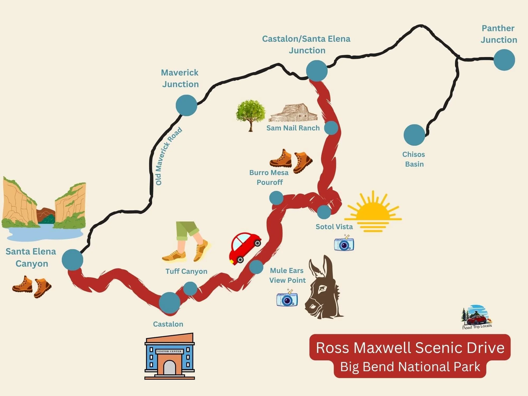
The Ross Maxwell Scenic Drive is a paved road on the western side of Big Bend National Park that runs from the main park road near Panther Junction down to Santa Elena Canyon. It’s about 30 miles one way, and packed with places to stop, hike, and take in the views. Along the way, you’ll see desert landscapes, volcanic rock formations, and river-carved canyons. The road is open year-round and suitable for all vehicles.
How to Get There
From Panther Junction Visitor Center, follow signs for Ross Maxwell Scenic Drive or Castolon/Santa Elena Canyon. The road begins near the center of the park and leads southwest toward the Rio Grande.
Length: 30 miles
Drive Time: 45 minutes to 2 hours one way, depending on stops
Road Type: Fully paved and accessible to all vehicles
Vehicle Restrictions: None, but drive slowly and watch for wildlife
Best Stops and Hikes Along Ross Maxwell Scenic Drive
Here are the best stops along the Ross Maxwell Scenic Drive, listed north to south:
1. Sam Nail Ranch
A short, easy trail leads to the remains of a historic ranch. You’ll see a still-operating windmill, a shaded grove of trees, and a surprising number of birds! It’s a peaceful spot for a quick break.
2. Sotol Vista Overlook
This overlook offers sweeping views across Big Bend’s desert floor all the way to Santa Elena Canyon. It’s one of the most photogenic spots on the drive, especially in the early morning or late afternoon light.
3. Lower Burro Mesa Pour-Off Trail
This 1-mile round-trip hike leads into a box canyon and ends at a dry waterfall chute. The geology is striking, and the trail is flat and easy, so it’s great for kids or a leg-stretching break.

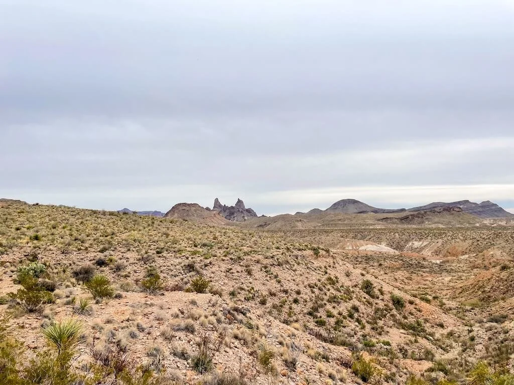
4. Mule Ears Viewpoint
A quick stop with views of the Mule Ears peaks, which are twin volcanic formations rising from the desert floor. This is a great place to take photos or have a snack with a view!
If you’re looking to stretch your legs, consider the Mule Ears Spring Trail, a 3.8-mile round-trip trail that starts at the viewpoint and winds through desert terrain to a small spring nestled at the base of the Mule Ears. It’s a moderately strenuous hike with classic Big Bend scenery and good chances for solitude.
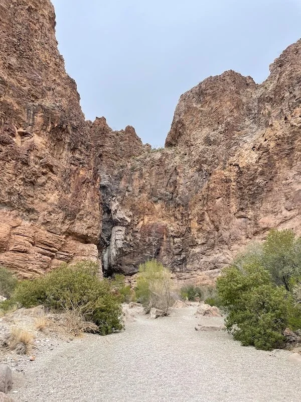
5. Tuff Canyon
A short trail leads into a narrow canyon made of compressed volcanic ash. It’s dramatic and easy to explore, with steep walls and interesting rock textures. This is a great family-friendly stop.
6. Castolon Historic District
Home to historic adobe buildings and a seasonal visitor center, Castolon offers a glimpse into Big Bend’s history.
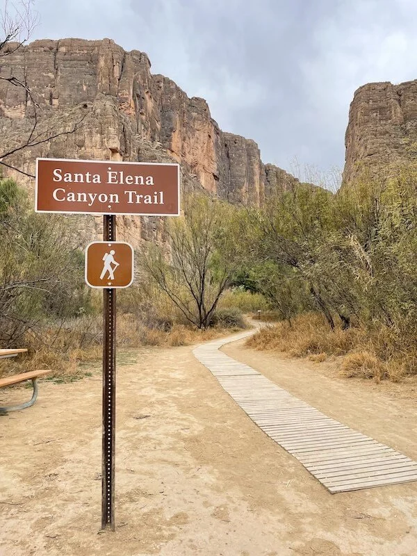
7. Santa Elena Canyon
The highlight of the drive! Towering canyon walls rise above the Rio Grande, and a 1.5-mile round-trip hike (the Santa Elena Canyon Trail) takes you up into the canyon itself for incredible views. Go early or late for cooler temps and softer light.


Ross Maxwell Scenic Drive Map
Where to Stay Nearby
Chisos Mountains Lodge: The only lodge inside the park, located in the Chisos Basin. We stayed in one of the park’s few pet-friendly cottages and loved the quiet setting, mountain views, and unbeatable stargazing.
Cottonwood Campground: Closest campground to the end of the scenic drive. It’s quiet and well-shaded, with easy access to Santa Elena Canyon.
Terlingua: Just outside the west entrance, Terlingua is a quirky desert town with rustic cabins, glamping tents, and local restaurants. It's about an hour from Santa Elena Canyon. Check out The Summit at Big Bend for truly unique stays, including the only cave hotel rooms in Texas!
Lajitas: A small resort town near the start of Highway 170. Great if you’re continuing your trip west. Lajitas Golf Resort offers adobe-style rooms and scenic views.

Chisos Mountain Lodge
When to Visit Big Bend National Park
The best time to drive the Ross Maxwell Scenic Drive is October through April. Temperatures are cooler, skies are clearer, and hiking conditions are ideal. Winter and early spring offer quiet mornings and some of the best stargazing in Texas.
We visited during a new moon in February and were blown away by the stars! With mild temps, fewer crowds, and golden desert light, winter is a fantastic time to experience this area.
Try to avoid summer if possible. It’s not uncommon for temps to reach over 100°F, and shade is limited. Plan hikes for early morning and bring plenty of water when visiting during summer months.
What to Know Before You Go
Limited Cell Service: Download maps ahead of time or grab one at Panther Junction Visitor Center on your way in.
Limited Services: Restrooms are available at Castolon and some trailheads, but not at every stop.
Pets: Allowed in cars and campgrounds, but not on trails.
Fuel Up First: No gas stations along the drive—fill up before entering the park.
Ross Maxwell Scenic Drive: Sample Itinerary
Want to make the most of the Ross Maxwell Scenic Drive? Here's a simple half-day route that follows the drive from north to south, hitting the highlights.
Note: Every stop along the way offers something unique, and what stands out most often depends on your interests. These are the places we personally found most memorable, but we’ll also note a few quick detours or lower-priority stops you can skip if time’s tight.
Start early from Panther Junction, Chisos Basin, or Maverick Junction and follow the road signs toward Ross Maxwell Scenic Drive
Stop at Sam Nail Ranch for a quick walk to the old windmill (skip if you’re short on time)
Pull over at Sotol Vista Overlook to take in the sweeping views
Stretch your legs at Burro Mesa Pour-Off Trail (1-mile round-trip)
Pause for a photo at Mule Ears Viewpoint
Explore the rock walls of Tuff Canyon (skip if you’re short on time)
Visit Castolon Historic District (skip if you’re short on time)
End your drive with a hike into Santa Elena Canyon along the Santa Elena Canyon Trail (this one’s a must do!)
This route takes around half a day, but you can linger longer at any stop or add more hikes depending on your pace and interests.
Loop Option: Old Maverick Road
If you're staying in Terlingua or entering/existing via the Maverick Junction Entrance Station, you can make a loop out of your drive via Old Maverick Road. This 14-mile dirt road runs between Santa Elena Canyon and the park's west entrance.
While it’s typically passable for most vehicles, it’s rough and washboarded, and the full drive takes about an hour. Avoid this route if rain is in the forecast as it can quickly become impassable and is often closed during or after storms. Check current conditions at a visitor center before heading out.
FAQs: Ross Maxwell Scenic Drive
Q: Is the Ross Maxwell Scenic Drive paved?
Yes, it’s fully paved and accessible with any vehicle. There are no technical driving challenges along the way, and the road is suitable for cars, SUVs, RVs, and trailers. That said, it's still wise to drive slowly and watch for wildlife or sudden dips in the road.
Q: How long does it take to drive Ross Maxwell Scenic Drive?
With just a few viewpoint stops, you can drive it in about 2–3 hours roundtrip. But if you want to truly experience the best of this Big Bend Scenic Drive, give yourself 5–6 hours or more.
Q: Can I bring my dog?
It’s not recommended to bring your dog on the Ross Maxwell Scenic Drive if you plan to hike or explore beyond roadside viewpoints. While pets are welcome in your vehicle and at developed areas like campgrounds and pullouts, but they aren’t allowed on trails or in the backcountry. This rule helps protect the park’s wildlife and your pet’s safety. You’ll want to keep pets leashed at all times, and never leave them unattended in a car, especially in the heat.
Q: Where can I find a Ross Maxwell Scenic Drive map?
You can pick one up at any visitor center on your way in (simply ask for a park map if you’re not handed one!) or download it ahead of time from the NPS Big Bend website. Paper maps are helpful since cell service is limited once you’re in the park. (You can generally find cell service near Chisos Basin Lodge and Panther Junction.)
Q: Is the Ross Maxwell Scenic Drive safe to drive?
Yes, it’s one of the most well-maintained roads in the park. However, flash floods can temporarily affect side roads and crossings, especially after summer monsoons or heavy winter rains. Check with rangers for up-to-date road conditions before heading out. (Heads up, this is especially true if you plan on looping back to Maverick Junction via Old Maverick Road. The road is often impassable following rain.)
Q: How long is the drive?
The Ross Maxwell Scenic Drive is approximately 30 miles one way, or 60 miles round trip. With detours, hikes, and photo stops, it makes for a perfect half- or full-day adventure.
Q: Are there restrooms along the way?
Restrooms are limited but available at the Panther Junction Visitor Center (near the start), the Castolon Historic District, and sometimes at select trailheads.
Why This Drive Is Worth It
The Ross Maxwell Scenic Drive offers a high-reward way to see Big Bend without committing to full-day hikes or remote backroads. With short trails, iconic views, and one of the most beautiful canyon hikes in the park, this drive gives you a little bit of everything. If Chisos Basin is the mountain escape, Ross Maxwell is the desert showcase—and both are well worth your time!
Related Posts
Travel Season, but make it local. That’s our motto for our 2025 Travel Season: Texas and the Southcentral. Follow along as we explore our own backyard here in Texas.